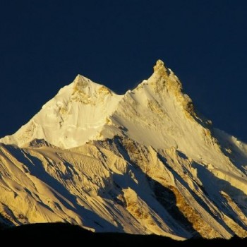
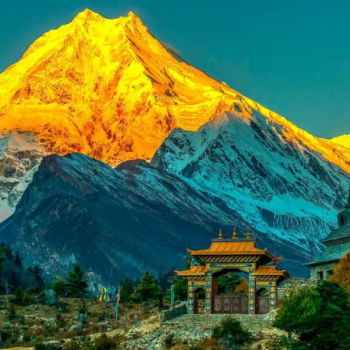
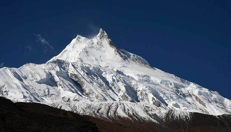
Close-up views of Manaslu (8,163m), Himlung Himal, Ganesh Himal, Nagdi Chuli, and the Annapurna range
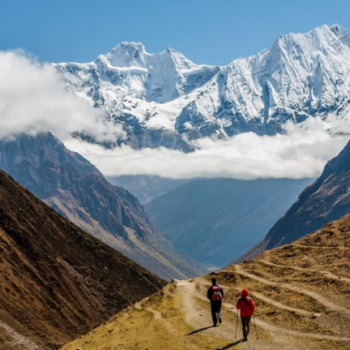
Larkya La Pass (5,160m) — one of the highest and most rewarding trekking passes in the Himalayas
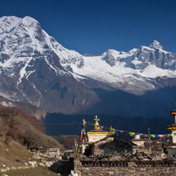
Encounters with Tibetan-Buddhist culture in villages like Samagaon, Samdo, and Lho
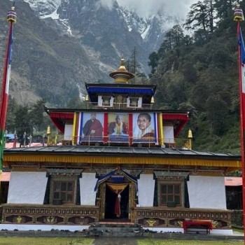
Visits to Pungen Gompa — ancient monasteries with sweeping mountain backdrops
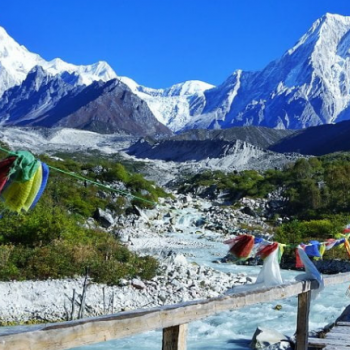
Prayer flags, mani walls, and chortens marking every ridge and river crossing
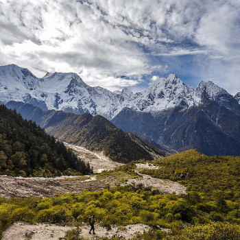
Trek through the Manaslu Conservation Area, home to snow leopards, red pandas, and Himalayan tahr
Dense rhododendron and oak forests that burst into colour in spring
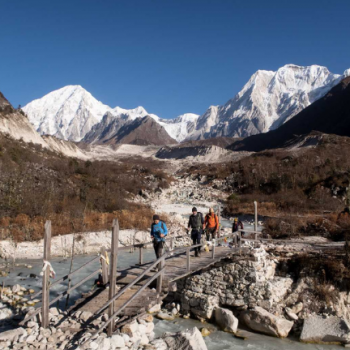
Rivers, waterfalls, and suspension bridges — the trail is a geography lesson in motion
Off-the-beaten-path Himalayan journey, with daily trekker numbers strictly controlled
Description
Introduction to Manaslu Circuit Trek
The Manaslu Circuit Trek is one of the best treks in Nepal. It goes around Manaslu, the world's eighth-highest mountain at 8,163 metres. The trek takes about 12 days and passes through deep river valleys, high mountain passes, and quiet Tibetan-style villages that most travellers never see.
The trail follows the Budhi Gandaki River from the lowlands all the way to the high Himalayas. You walk through forests, cross suspension bridges, pass ancient monasteries, and climb up to the Larkya La Pass at 5,160 metres. After crossing the pass, the trail descends into the Annapurna region. The full route forms a complete circle around Manaslu, which is why it is called a circuit.
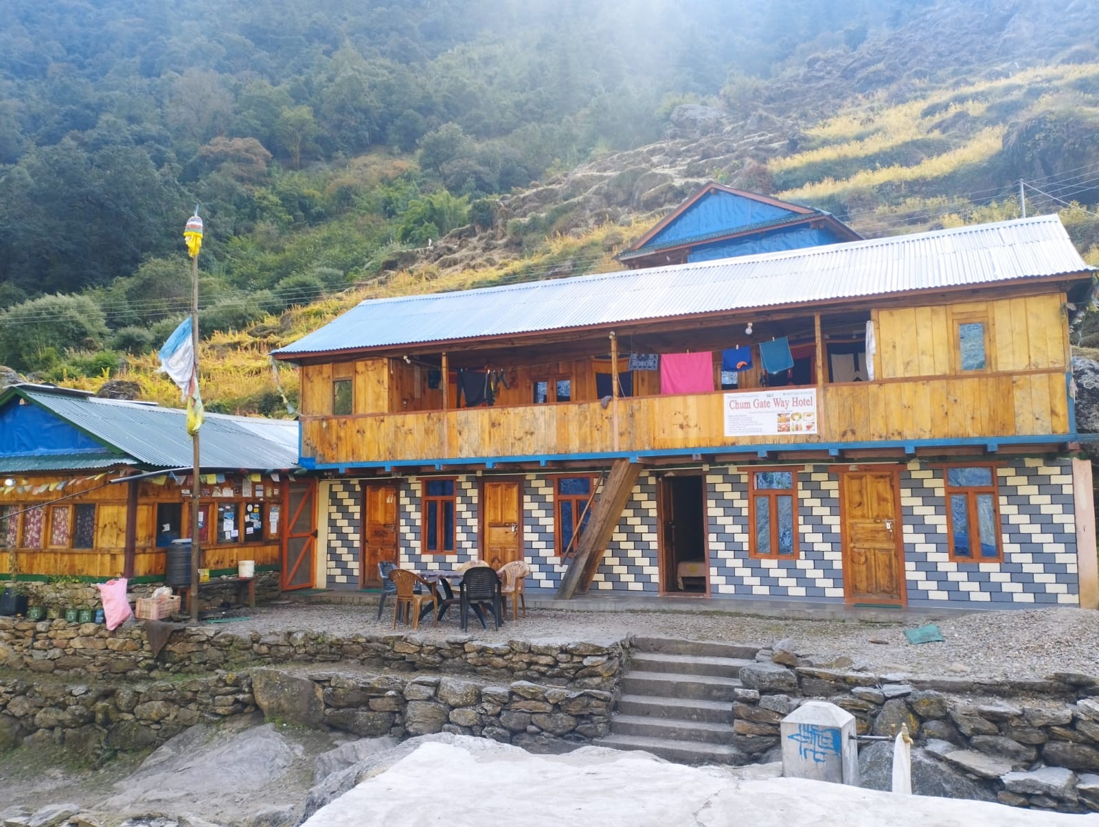
The Manaslu Circuit is different from the Everest Base Camp Trek or the Annapurna Circuit Trek. Because it is a restricted area, fewer trekkers are allowed in. This means the trail is quiet, the villages feel genuine, and the mountain scenery feels much more personal. You will walk for hours without seeing another group. The teahouses are small and family-run. The local people — mostly Gurung and Tibetan communities — live the same way they have for generations.
This trek is suitable for trekkers who are fit and healthy. You do not need any special climbing skills, but you should be comfortable walking 5 to 8 hours a day on steep and uneven paths. If you have done multi-day hiking before, the Manaslu Circuit Trek is a great next step. First-time trekkers can also join with good physical preparation. Mount Mania provides full support, experienced guides, and a safe itinerary for all skill levels.
Why Book with Mount Mania?
Choosing the right trekking company is not just about price — it is about trust, expertise, and knowing that someone who genuinely understands the mountains has your back. Mount Mania was founded by passionate Himalayan trekkers and local mountain professionals who have spent decades navigating Nepal's most remote trails. Here is what makes us different.
Local Expertise
Our guides are not simply trail walkers — they are certified, experienced professionals who grew up in or near the Himalayas. They know Manaslu's weather patterns, the subtle signs of altitude sickness, the best acclimatisation strategies, and the cultural protocols that will earn you genuine warmth from village communities along the route. When you trek with Mount Mania, you have a knowledgeable companion, not just a path-finder.
Safety as a Non-Negotiable
Every Manaslu Circuit Trek we operate follows a carefully designed itinerary that prioritises acclimatisation and pacing above all else. Our guides carry pulse oximeters, first aid kits, and emergency oxygen. We maintain real-time communication with our Kathmandu operations team throughout your trek and have established protocols for emergency descent and helicopter evacuation if ever required. Your safety is not a checkbox — it is the foundation of everything we do.
Full Permit & Logistics Management
The Manaslu restricted area permit process is notoriously complex. We handle everything: the Manaslu Conservation Area Permit (MCAP), the Annapurna Conservation Area Permit (ACAP), the Restricted Area Permit (RAP), TIMS cards, and all associated liaison requirements. You arrive in Kathmandu and focus on your adventure — we handle the bureaucracy.
Responsible & Sustainable Trekking
Mount Mania is committed to leaving the Manaslu region better than we found it. We pay our porters above the recommended daily wage, ensure they have adequate clothing and shelter, and cap porter loads at safe levels. We carry out our own waste, support locally-owned teahouses, and contribute a portion of every booking to conservation initiatives in the Manaslu Conservation Area. Trekking responsibly is not a marketing tagline for us — it is a moral commitment.
Customisation & Flexibility
No two trekkers are the same. Whether you want to add a side trip into the Tsum Valley, extend your itinerary for extra acclimatisation days, or arrange a private group with custom menu planning, Mount Mania can build the Manaslu trek package that suits your specific goals, timeline, and budget. Contact us to start the conversation.
Booking Process
We have made booking your Manaslu Circuit Trek as straightforward as possible. Here is how it works from first inquiry to departure day:
Initial Inquiry: Send us a message via our website contact form, email, or WhatsApp. Tell us your preferred dates, group size, fitness level, and any specific requirements. We will respond within 24 hours.
Personalised Proposal: Our team will prepare a customised itinerary and detailed cost breakdown tailored to your dates and group. We are happy to adjust itineraries, add rest days, or include side trips.
Booking Confirmation: Once you are happy with the proposal, a 10% deposit secures your spot and triggers our permit application process. We accept bank transfers and credit cards
Documentation: We will request copies of your passport, travel insurance details, and an emergency contact. All documents are handled with strict confidentiality.
Pre-Trip Briefing: Approximately 2 weeks before your departure, we will send a comprehensive pre-trip pack covering gear lists, health advice, local customs, and Kathmandu logistics. We are also available for a video call to answer any last-minute questions.
Arrival in Kathmandu: Our team will meet you at the airport, transfer you to your hotel, and hold an in-person orientation briefing the evening before your trek begins.
Balance Payment: The remaining 90% of the trek cost is due upon arrival in Kathmandu, before the trek departs. Read our Trip Booking details.
12 Days Manaslu Circuit Trek Itinerary
Expand AllHide All
Day 1: Drive from Kathmandu to Soti Khola (160km / 8-9 hrs. 710m)
Today, you will head out to the starting point of your trek i.e. Solti Khola. You will take a bus from Kathmandu to Soti Khola. The route of the bus takes you along the Prithvi Highway. The road you through the middle hills till Malekhu. From Malekhu, a 30km road takes you north along the Trishuli river as you head towards Dhading Besi. A further 35-kilometer drive along a dirt road leads you to Arughat. As the road gets winding up to Gola Bhanjyang, you can see panoramic views Ganesh, Baudha and Manaslu Himal. A further 3 hours of ride leads you to Soti Khola. The bus ride up to Soti Khola is 8-9 hours.
Meals: Breakfast, Lunch & Dinner
Accommodation: Teahouse / Lodge
Distance: 160km / 8-9 hrs
Altitude: 710m
Day 2: Trek from Soti Khola to Maccha Khola (11km/ 5-6 hrs. 900m)
You will start your trekking journey today. The initial portion of today’s trek takes you along a gradual uphill through beautiful Sal forests. You will then walk past forested and terraced ridges and numerous waterfalls along the way. At times, the trail also narrows. You might also find yourself clinging to the sides of cliffs sometimes.
The trail then descends as you walk past rice paddies before climbing up to Labubesi (885m/2,800ft). From the village of Labubesi, you will trek to a suspension bridge Nauli Khola falls. You will then descend to gravel banks along the river before hiking gently up to Machha Khola village(900 meters). The trek from Soti Khola to Machha Khola is 6-7 hours long.
Meals: Breakfast, Lunch & Dinner
Accommodation: Teahouse / Lodge
Distance: 11km/ 5-6 hrs
Altitude: 900m
Day 3: Trek from Maccha Khola to Jagat (22km / 7-8 hrs. 1410m)
After breakfast, you will head out on a 6-7 hour trekking journey to Jagat (1410 meters). After crossing Machha Khola, you will trek gently up to the tiny village of Khorla Bensi. From there, you will get to the natural hot springs at Tatopani. This trail is also quite challenging.
After crossing a short forested path, you will reach a single teahouse at Doban. Above the village of Dobhan, Budhi Gandaki river descends rather impressively to a series of rapids. The river is quite calm beyond this steep slope. A further trek from Dobhan leads you to Lauri, where you will cross the river on a suspension bridge. Finally, you will climb on a high path to the fields of Jagat, where you will spend your night.
Meals: Breakfast, Lunch & Dinner
Accommodation: Teahouse / Lodge
Distance: 22km / 7-8 hrs
Altitude: 1410m
Day 4: Trek from Jagat to Deng (20km / 7-8 hrs. 1800m)
After breakfast at a teahouse in Jagat, you will embark on your trekking journey. A gentle uphill trek followed by a trek along level fields takes you to a suspension bridge over Budhi Gandaki. After crossing this suspension bridge, you will get to Philim. Philim is a large Gurung village that is home to small serene monasteries, stupas and prayer flags. You will have your lunch in Philim.
After lunch, you will trek through a flat leveled path. This path is inside pine and rhododendron forests. During the trek, you will also cross a few bridges that overlook quaint villages afar. After trekking for 6-7 hours from Jagat, you will arrive at Deng (1080 meters). Deng is home to a few houses. You can also enjoy an amazing waterfall lying at a small distance from Deng. This is an agricultural village that is famous for its potatoes, and buckwheat, barley, wheat, cabbage, & spinach.
Meals: Breakfast, Lunch & Dinner
Accommodation: Teahouse / Lodge
Distance: 20km / 7-8 hrs
Altitude: 1800m
Day 5: Trek from Deng to Namrung (19.5km / 7-8 hrs. 2630m)
Deng is a village that is the point of entry to Kutang or lower Nupri (part of Tibet until the 1840s): It is a primarily a Gurung settlement with the culture of Tibetan Buddhism. They have their own language. The trail from Deng takes you along a winding path to Rana. After trekking past a series of uphills and downhills, you will get to a log bridge. After crossing a tributary from the bridge, you will get to an isolated water mill. Then you will descend gently along the trail to Bihi Phedi, which lies high above the river.
Beyond Bihi Phedi, the trail descends as you cross the Serang Khola. Then, you will trek along a winding path that shapes up like an S. The path lies between sheer basalt walls. You can also see huge rocky crags to the right. You will also have splendid views of the waterfall above the maize and wheat fields. As you trek towards the northeast direction, the valley broadens. After trekking past a bridge and mani stone walls, you will reach the attractive village of Ghap (2,250m/ 7,382ft). Past the village of Ghap, you will trek through bamboo, rhododendron and oak forests. On some days, you can also see birds like Impeyan pheasant (also known as Himalayan Monal)
This trail is above the steep descent of the river. For a short duration of time, you will trek to the north bank. Then you will head back towards the southern bank after crossing a bridge. After trekking for one hour from the bridge, you will reach Namrung. Namrung also has a police checkpoint for permits. Just before you get to Namrung, the trail overlooks Tum Khola from Tibet. This adds to the volume of water in Budhi Gandaki in the confluence. The trek from Deng to Namrung (2630 meters) is 6-7 hours long.
Meals: Breakfast, Lunch & Dinner
Accommodation: Teahouse / Lodge
Distance: 19.5km / 7-8 hrs
Altitude: 2630m
Day 6: Trek from Namrung to Samagaon (18km / 7-8 hrs. 3530m)
Namrung is a Tibetan village and serves as an entrance to Upper Nupri. As you trek past a mix of forest and barley fields, you will reach Lihi. You can see impressive chortens as well as great views of Himal Chuli (7,893m/25,897ft) and Ganesh Himal. The trail then descends before entering a valley as you cross the Hinang Khola. After crossing Hinanag river on a bridge, you will trek along a steep uphill to a chorten, which offers spectacular views of Ngadi Chuli (7,873m/25,831ft).
As you trek further up a steep ridge, you will reach Lho. You can also visit a large monastery called Ribung monastery in Lho. You will then trek down a steep uphill before you reach Damonan Khola tributary. After trekking past a plateau, you will get to Shyala village (3,520m/11,549ft). Shayala overlooks many beautiful peaks like Himal Chuli (7,893m/25,897ft), Peak 29 (Ngadi Chuli, 7,873m/25,831ft); and Manaslu (8,156m/26,760ft).
As you continue trekking, you will get to a bridge over Numla Khola. The trail then takes the left of Pungyen Gompa. After trekking for 6-7 hours from Namrung, you will get to Samagaon (3530 meters). Kargyu Chholing Monastery stands against a forested moraine around the edge of this village. From Samagaon, you can only see the upper sections of Manaslu and the Naike ridge.
Meals: Breakfast, Lunch & Dinner
Accommodation: Teahouse / Lodge
Distance: 18km / 7-8 hrs
Altitude: 3530m
Day 7: Trek from Samagaon to Pungyen gompa. Then Back to Samagaon (5/ 6 hrs. 3870m)
Today, you will explore the village of Samagaon, which is the regional center of Nupri. You will also get to know about the culture and architecture in the region: only potatoes and barley flourish in the short summers at this altitude. Most of the people in this village weave clothes from sheep or Tibetan imported wool. They are also involved in the manufacture of hooked rugs for trade with Tibet.
You will visit the Labrang (Lama’s Place) Gompa and the Kargyu Chholing Monastery in Samagaon, The history of these monasteries dates back some 500 years ago. Many people ascribe the history of these monasteries to its earlier Tibetan settlers. The monastery has impressive wooden carvings. All in all, there are eight temple buildings. The largest of them is the Pemba Chholing Gompa. It is home to an impressive statue of Guru Rinpoche.
A gentle hike past the monastery leads you to Birendra Tal (3,450m/11,319ft). This lake lies below Manaslu Glacier. You can also trek for close to 3 kilometers to get to a hilltop or a stony beach which offers wonderful views of Manaslu. You can also follow a trail towards Samdo to a bridge over the stream from the lake. After trekking for 5-6 hours, you will get to Manaslu Base Camp.
You can also trek to Pungyen Nunnery (3,870m/12,697 ft). It lies above Pungyen Glacier. You can get sumptuous views of the Nadi ridges and Manaslu from near the gompa.
Meals: Breakfast, Lunch & Dinner
Accommodation: Teahouse / Lodge
Distance: 5/ 6 hrs
Altitude: 3870m
Day 8: Trek from Samagaon to Samdo (8.5km / 3-4 hrs. 3860m)
The initial part of today’s trek descends towards Budhi Gandaki. The trail is in the north towards the lake. You will walk along the Base Camp trail as you encounter several mani walls as the valley widens. The trek is relatively easy and lies a shelf above the river. You will walk past the forests of juniper and birch which surround Kermo Kharka. The trail then descends to a wooden bridge as you cross the Budhi Gandaki river.
Then you will trek along a steep uphill to a ridge that lies above the confluence of Budhi Gandaki and Mayol Khola. You will encounter a stone arch, and fields before you get to the entrance of the village. Although the place is an attractive one, it is primarily a yak and goat herding area. The village only turned out as a settlement in the late 1950s when Tibetans fled Tibet.
As you trek past these fields, you will get to several sets of flags on a high ridge. Here, you can catch superb panoramic views of Samdo Peak (6,335m/20,785ft) and its glacial basin, the Sama Valley, Manaslu range, Syacha Glacier, Dharamsala, and Larkya La pass. After trekking for 4-5 hours from Samagaon, you will reach Samdo (3860 meters). Samdo is the last village before Gho, in the Manang District. Only informal kharkas (with lodges) lie between these villages.
Meals: Breakfast, Lunch & Dinner
Accommodation: Teahouse / Lodge
Distance: 8.5km / 3-4 hrs
Altitude: 3860m
Day 9: Trek from Samdo to Dharamsala (6.5km / 3-4 hrs. 4460m)
You will trek past the fields in the northern village as you cross the Budhi Gandaki the final time. This will take place in the Larkya Bazaar site. The flow of the river takes it to the Pana Danda Valley in the north. You will then take the westward trail. You will trek past grassy slopes with scrub juniper, rhododendron and lichen covered granite. This trail is just above the Syacha Khola Valley. Along the way, you can also see the origin of Syacha Glacier, which descends from the Manaslu North ridge.
The trail works heads towards the Larkya Glacier. After trekking past the Larkya La Phedi, you will get to a settlement called Dharamsala (4460 meters). Today’s trek from Samdo to Dharamsala is 4-5 hours long. A short walk from your guesthouse will take to a place with better views of the Larke (6,249m/20,503ft) and Naike (6,291m/20,641ft) peaks.
Meals: Breakfast, Lunch & Dinner
Accommodation: Teahouse / Lodge
Distance: 6.5km / 3-4 hrs
Altitude: 4460m
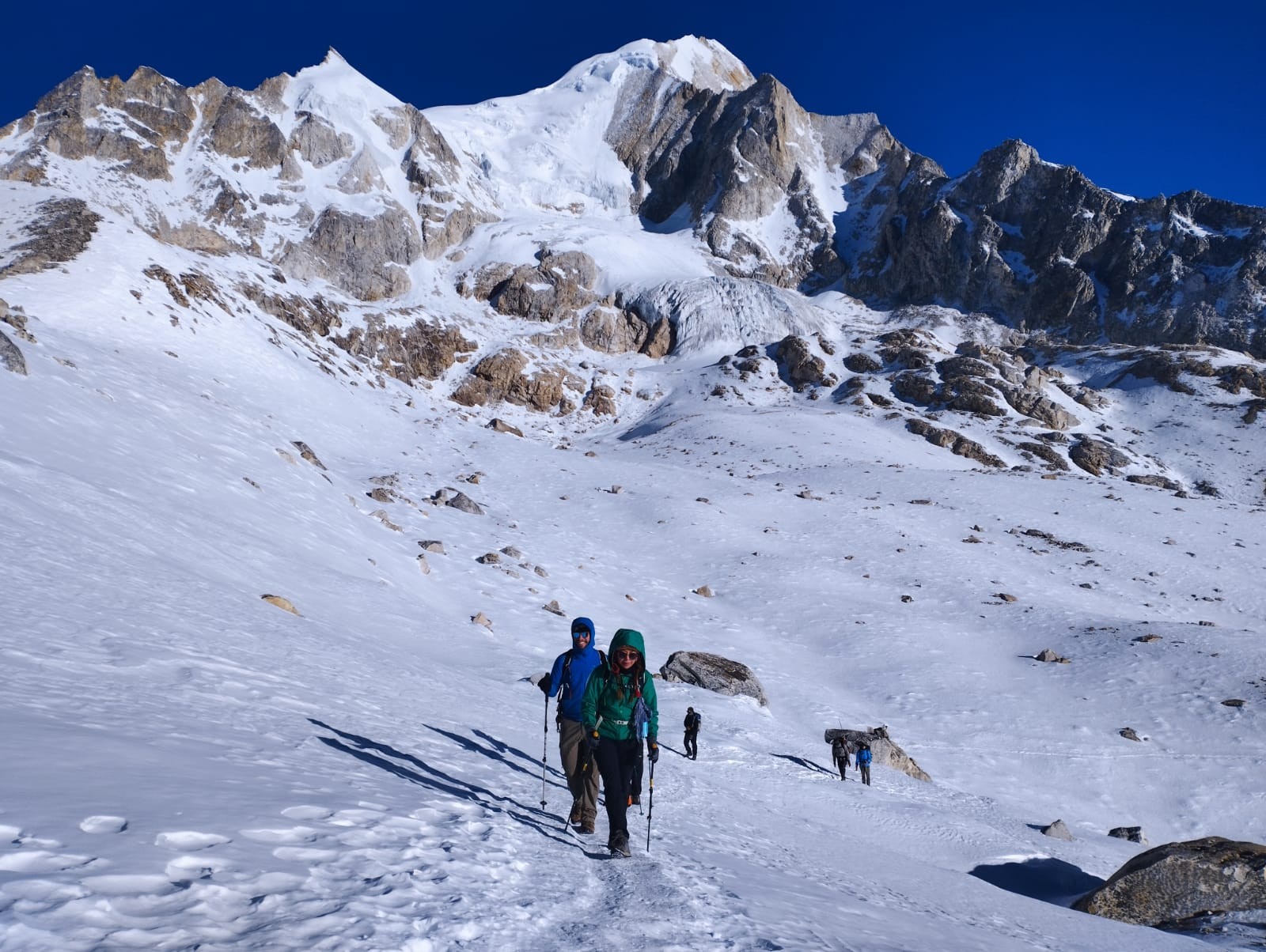
Day 10: Trek to Bhimthang via Larkya La Pass (24.5km / 8-9 hrs. 3720m)
Today you trek for 3-5 hours to ascend 800m/2,600ft to get to Larkya La Pass (5160 meters). You will then descend for 3-4 hours losing 1,500m/4,900 in altitude to get to Bimthang(3720 meters). If the wind blows, it can get really cold along the way. You have to be extra careful if you encounter ice and snow along the way.
The trekking trail from Dharamsala takes you along a gentle ascent to a ridge. Then will be a long gentle climb to the moraine. The trail along the northern moraine of the Larke Glacier is not quite steep. However, the trek is quite long and rocky. So you might find this a bit challenging. From the glacier, you can see the Larke Peak (Larke Himal) and Pawar Peak (Cheo Himal) on the south and north of the glacier respectively.
From the pass, you will trek uphill to an ablation valley. The trail then drops down to the first of four small scattered frozen lakes. As you trek uphill to the glacial moraine from the left, you will get to the first set of summit flags. The trail overlooks the Tibetan border ranges beyond Samdo Peak on the eastern side. There is a long moraine-ridge that is parallel to the Larke wall. A set of flags separates the Larke Wall. These flags are the markers of the border between the Manaslu and Annapurna Conservation areas.
This place is a wonderful point to see the various peaks like Pawar Peak (6,620m/21,720ft), Cheo Himal (6,820m/22,376ft), the Himlung pyramid (7,126m/23,380ft), Gyaji Kung (7,030m23,065ft), Kang Garu (6,981m/22,905ft) plus Annapurna II (7,937m/26,041ft).
After spending some time in Larkya La pass, you will start your descent begins from these prayer flags. The trail descends steeply from the moraine. Then you will get to a set of steep zigzags until you reach Dangboche Kharka (4,450m/14,600ft). The trail from Dangboche Kharka is not really steep. The trail winds along the lateral moraine of the Salpudanda/Bimthang glacier before getting to Bimthang Valley.
Meals: Breakfast, Lunch & Dinner
Accommodation: Teahouse / Lodge
Distance: 24.5km / 8-9 hrs
Altitude: 3720m
Day 11: Trek from Bhimthang to Dharapani (22km / 7-8 hrs. 1860m)
Bhimthang is a beautiful settlement that gives you views of the Kechakyu Himal on the north and Manaslu’s northeast face. Bhimthang serves as a settlement of the people of Samdo village in the summer season. It was also an important trading post before the border to Tibet closed down. It was also a center of the Tibetan Khampa warriors around 1970.
Today’s trek begins as you walk past the Bimthang Plain. You will descend along a trail to cross the stony glacier before heading up a moraine to enter rhododendron and pine forest. All along this route, you will get wonderful views of Larke, Manaslu, Nadi and Chuli Himals. As you descend further, you will get to Hompuk and Sangura Kharka before reaching Karche. From Karche, you will trek past terraced fields and a steep uphill until you reach Gho.
The trail from Gho takes you through farmlands to Tilje (2,300m/7,546ft). From there, you will descend rapidly towards the Marsyangdi Valley in Thonje (1,965m/6,447ft) You will then join the new road along the main Annapurna Circuit route in Dharapani(3560 meters). Today’s trek is 5-6 hours long.
Meals: Breakfast, Lunch & Dinner
Accommodation: Teahouse / Lodge
Distance: 22km / 7-8 hrs
Altitude: 1860m
Day 12: Drive from Dharapani to Kathmandu or Pokhara (8-9 hrs. 1320m)
Today, you will head back to Kathmandu. You will follow the Prithvi Highway en route to Kathmandu. To reach our destination, we need to drive for about 7-8 hours by jeep and 9-10 hours by local bus. On the way, you can view natural waterfalls, rice-field, local house, forest, and streams.
Three meals a day (12 Breakfast, 12 Lunch, and 11 Dinner) during the trek
Local Bus Ticket (Kathmandu to Soti Khola)
Local Bus Ticket (Dharapani to Kathmandu)
12 days English Speaking Trekking Guide with Insurance, Transportation, Food and Accommodation
All Trekking Permits (ACAP, MCAP and Manaslu Special Permit)
Daily seasonal fresh fruits after dinner
A first aid kit carried by the guide (Oximeter to measure your oxygen and pulse in high altitude)
All Government and Local taxes
Cost Excludes
International Flight Ticket and Nepalese Visa Fee
Hotel & Meals in Kathmandu
Extra night accommodation in case of early arrival, late departure, and early return from the trek (due to any reason) than the scheduled itinerary
Personal expenses (WiFi, Phone calls, Laundry, Bar bills, Battery Recharge, Water, Shower, and Tea / Coffee)
Other costs not mentioned in 'Cost Includes' section
Travel and Rescue Insurance
Tips for Guides, Porters, and Drivers
Optional
Private jeep Kathmandu to Machha khola USD220$
Private jeep Dharapani to Kathmandu to USD250$
Kathmandu Hotel Per Night Twin Sharing On BB USD 60$
Use of sleeping bag & Duffel bag (if you don’t have your own, To be return after trip completed).
PRICES & DATES
Please Select Month
Trip Dates
Availability
Price
16 Apr, 2026 - 27 Apr, 2026
Guaranteed
US$875
17 Apr, 2026 - 28 Apr, 2026
Guaranteed
US$875
18 Apr, 2026 - 29 Apr, 2026
Guaranteed
US$875
19 Apr, 2026 - 30 Apr, 2026
Guaranteed
US$875
20 Apr, 2026 - 01 May, 2026
Guaranteed
US$875
Useful Information
Manaslu Circuit Trek Weather
Timing is everything in the Himalayas. The Manaslu Circuit Trek is an all-season route in theory, but the experience varies dramatically depending on when you visit.
Autumn — October to November
This is the prime season for trekking in Nepal, and the Manaslu Circuit is at its most spectacular. Skies are clear and stable, visibility is exceptional, and daytime temperatures at lower elevations are pleasantly warm (15–22°C). At altitude, expect cold nights (-5 to -15°C), particularly around Dharamsala and the Larkya La crossing. The trail is busy relative to other times of year — though 'busy' on Manaslu is still a fraction of the Everest or Annapurna crowds.
Spring — March to May
Spring is the second-best window for the Manaslu Circuit Trek. Rhododendron forests erupt in colour along the lower sections of the trail, making it a visually stunning time to trek. Temperatures are warming, though afternoon cloud build-up becomes increasingly common by late April and May. The Larkya La crossing is generally safe in spring but can be challenging if late-season snowfall has occurred.
Winter — December to February
Winter trekking on the Manaslu Circuit is possible but demanding. Temperatures at the Larkya La can drop to -20°C or below, and snowfall can close the pass entirely. Teahouses along the higher sections may be closed. That said, winter trekkers are rewarded with near-total solitude and some of the clearest mountain views of the year. This option is only recommended for experienced cold-weather trekkers with the right gear and a flexible itinerary.
Monsoon — June to September
The summer monsoon brings heavy rainfall, leeches on the lower trails, landslide risk, and persistently poor visibility. While the Manaslu region receives slightly less rainfall than southern Nepal due to the rain shadow effect at higher elevations, the lower gorge sections become genuinely hazardous. We do not recommend the Manaslu Circuit Trek during the monsoon months for most trekkers.
Manaslu Circuit Trek Altitude Profile
The Manaslu Circuit Trek is one of the most altitude-intensive trekking routes in Nepal, and understanding the elevation gain is critical for a safe and enjoyable journey. The trek begins in Soti Khola at approximately 700 metres above sea level — a warm, subtropical starting point. Over the first few days, the trail climbs steadily through the Budhi Gandaki gorge, passing through Machha Khola (900m), Jagat (1,410m), and Deng (1,840m). This gradual ascent is intentional: the lower sections of the trek serve as a natural warm-up for the higher altitudes ahead.
The views of Manaslu's north face here are extraordinary, and most trekkers feel a noticeable change in air density. Our itinerary builds in a rest day at Samagaon (3,530m), the last major village before the high passes, to allow proper acclimatisation. We strongly encourage a side excursion to Manaslu Base Camp (4,800m) from Samagaon — not only for the staggering views but because the altitude gain and return to lower sleeping elevation is one of the most effective acclimatisation strategies available.
From Samdo (3,875m), the trail climbs steadily to Dharamsala (also known as Larkya Phedi, at approximately 4,470m), which serves as the high camp before the Larkya La Pass crossing. The pass itself, at 5,160 metres, is the physical and emotional centrepiece of the entire trek. The crossing is long — typically a 6 to 8 hour day — and requires an early start to take advantage of stable morning weather.
After crossing Larkya La, the descent into Bimthang (3,590m) provides genuine relief. The body begins to recover rapidly at this altitude, and the views back toward Manaslu from the Bimthang meadows are among the most beautiful on the entire route. The final days descend through Dharapani (1,943m) back toward lower elevations.
Altitude sickness is a real risk above 3,000 metres, and our team is trained to recognise its symptoms: persistent headache, nausea, loss of appetite, fatigue, and dizziness. The golden rule is simple — never ascend to sleep at a higher altitude if symptoms are present. Our guides follow this rule without exception, and we encourage every trekker to review altitude sickness awareness materials before departure.
Read Before Booking This Trip
Fitness Expectations
The Manaslu Circuit Trek requires a solid cardiovascular base. You will be walking 5 to 8 hours per day on uneven terrain for up to 12 days, at elevations that will challenge even fit trekkers. We recommend building your fitness at least 8 to 12 weeks before departure through regular hiking, stair climbing, or running. Yoga and core strength work are also highly beneficial for long days on the trail.
Trek Difficulty
We rate the Manaslu Circuit as a moderate-to-challenging trek. It does not require technical mountaineering skills or the use of ropes and ice axes under normal conditions. However, the Larkya La crossing involves a long, high-altitude day and may involve ice or compacted snow in colder conditions. Trail conditions can be rocky, steep, and exposed. Prior multi-day trekking experience is strongly recommended. The total length of the Manaslu Circuit trek is around 177 kilometers. You will be trekking for 10 days covering a distance of 15-20 kilometers every day.
Travel Insurance
Travel insurance that covers high-altitude trekking (to at least 5,500m) and helicopter evacuation is an absolute requirement for all Mount Mania Manaslu trek packages. Helicopter evacuation from a remote Himalayan location can cost upwards of USD 5,000. Please ensure your policy covers this explicitly and carry your insurance documentation at all times on the trek.
Health Considerations
Consult your doctor before booking if you have any cardiovascular, respiratory, or blood pressure conditions. We strongly recommend a prescription for Diamox (acetazolamide) from your doctor as a preventative measure against altitude sickness. Ensure all routine vaccinations are up to date, and consider vaccinations for hepatitis A/B, typhoid, and tetanus. Dental check-ups before a remote trek are often overlooked but genuinely worthwhile.
Visa & Travel Preparation
Most nationalities can obtain a Nepal visa on arrival at Tribhuvan International Airport in Kathmandu, or via the Nepal e-Visa portal before travel. A standard 30-day tourist visa costs USD 30. We recommend applying online in advance to avoid queues on arrival. Ensure your passport has at least 6 months of validity from your intended departure date from Nepal.
Packing List for Manaslu Circuit Trek
Packing for the Manaslu Circuit Trek requires careful thought. The key is layering — the trail spans subtropical valleys and sub-zero passes within the same trip.
Clothing
Moisture-wicking base layers (top and bottom) — 2 sets minimum
Mid-layer fleece or insulating jacket
Waterproof and windproof outer shell jacket and trousers
Down jacket (rated to -10°C or below)
Trekking trousers — lightweight and quick-drying
Warm hat, balaclava, and sun hat
Lightweight gloves and heavy insulated gloves for the pass
Wool or synthetic thermal socks — 4 to 6 pairs
Buff or neck gaiter
Footwear
Broken-in waterproof trekking boots with ankle support — this is the most important item on this list
Camp shoes or sandals for teahouse evenings
Waterproof gaiters (highly recommended for the Larkya La crossing)
Accessories & Gear
Trekking poles — adjustable, with carbide tips
Headlamp with spare batteries
Sunglasses with UV400 or glacier rating
Sunscreen SPF 50+ and lip balm
35–45 litre daypack with rain cover
Sleeping bag rated to -15°C (or liner if renting at lodges)
Water purification tablets or a UV pen filter
Reusable water bottles — 1 litre capacity minimum
Personal first aid kit: blister treatment, ibuprofen, loperamide, rehydration salts
Required Documents
Passport (original + 2 photocopies)
Travel insurance policy (printed and digital)
Nepal visa / e-Visa approval
Emergency contact card
USD cash — ATMs are not available on the Manaslu trail
Optional Gear
Camera and extra batteries (cold drains batteries rapidly)
Lightweight solar charger or power bank
Trekking journal
Packable down booties for camp evenings
Powerbank
Note: Quality gear rental (down jackets, sleeping bags, trekking poles) is available in Kathmandu's Thamel district at very reasonable rates if you prefer not to travel with bulky items.
Trip Gallery
FAQs
Can I get a visa on arrival in Nepal?
Yes, most nationalities can obtain a Tourist Visa upon arrival at Tribhuvan International Airport (TIA) in Kathmandu. You can fill out the form online before arrival or use the kiosks at the airport. Be sure to have USD cash for the visa fee ($30, $50, or $125 depending on the duration).
Do I need to book in advance?
For the Manaslu Circuit, advanced booking (at least 2–4 weeks prior) is highly recommended. Because this is a restricted area, we need time to process your special permits, which require your passport copies, visa page copy and photos once you arrive in Kathmandu.
How do you transfer me from Tribhuvan International Airport to my hotel?
Our representative will meet you outside the arrivals gate holding a sign with our Company Logo. From there, you'll be driven via private vehicle directly to your hotel in Thamel or the surrounding area, ensuring a smooth start to your journey.
Can I do the Manaslu Circuit without a guide?
No. The Government of Nepal classifies Manaslu as a restricted area. It is mandatory to have a licensed trekking guide and a minimum of two trekkers in a group to obtain the necessary permits.
Can your guide speak English?
Absolutely. All our guides are fluent in English and are trained to explain the culture, geography, and safety protocols clearly throughout the journey.
How experienced is your guide? How well do they know the Manaslu region?
Our guides have years of experience specifically in the Manaslu region. They are certified by the Nepal Government and have completed high-altitude medical training to ensure your safety and an enriched cultural experience.
Do I have to issue my own permit for the Manaslu Circuit Trek?
No. As an individual, you cannot apply for these permits yourself. Only registered Nepalese trekking agencies can apply for the Manaslu Restricted Area Permit (RAP) on your behalf.
What documents do you need for the permits?
We require a clear scan of your passport (valid for at least six months) and a copy of your Nepal visa (once you arrive in Kathmandu)
What permits do I need for the Manaslu Circuit Trek?
You need three main permits:
Manaslu Restricted Area Permit (RAP)
Manaslu Conservation Area Project (MCAP)
Annapurna Conservation Area Project (ACAP)
Chumnubri Rural Municipality Fee
Mount Mania as a registered trekking agency in Kathmandu, we will apply all of these four permits.
Why do I need an ACAP Permit for the Manaslu Trek?
The Manaslu Circuit trail officially ends in Dharapani, which falls within the Annapurna Conservation Area. Therefore, an ACAP permit is required to legally exit the region through the Besisahar route.
What is covered in the amount I pay for the trek?
Typically, our packages include all necessary trekking permits, ground transportation from starting to end of the trip, an English-speaking trekking guide, strong porters, mountain teahouse accommodation during the trek, and three meals a day with one tea / coffee a day.
How much money do you recommend to take on the trek?
We suggest carrying $300–$500 (in Nepalese Rupees) for personal expenses such as Wi-Fi, hot showers, charging electronic devices, bottled drinks, and tips for the staff.
What are the extra costs of the trek?
Extra costs include your international flights, Nepal visa fee, travel insurance (mandatory), tips, and personal trekking gear. On the trail, extra costs include snacks, soda/alcohol, and hot showers.
How much does it cost to trek the Manaslu Circuit?
Prices vary based on group size and service level, but a standard 14–18 day trek generally ranges between $1,200 and $1,800 USD.
How far is Manaslu from Kathmandu?
The drive from Kathmandu to the starting point (Soti Khola or Machha Khola) is approximately 140–160 km. However, due to mountain terrain, the drive takes 7 to 9 hours.
How high will I go on the Manaslu Trek?
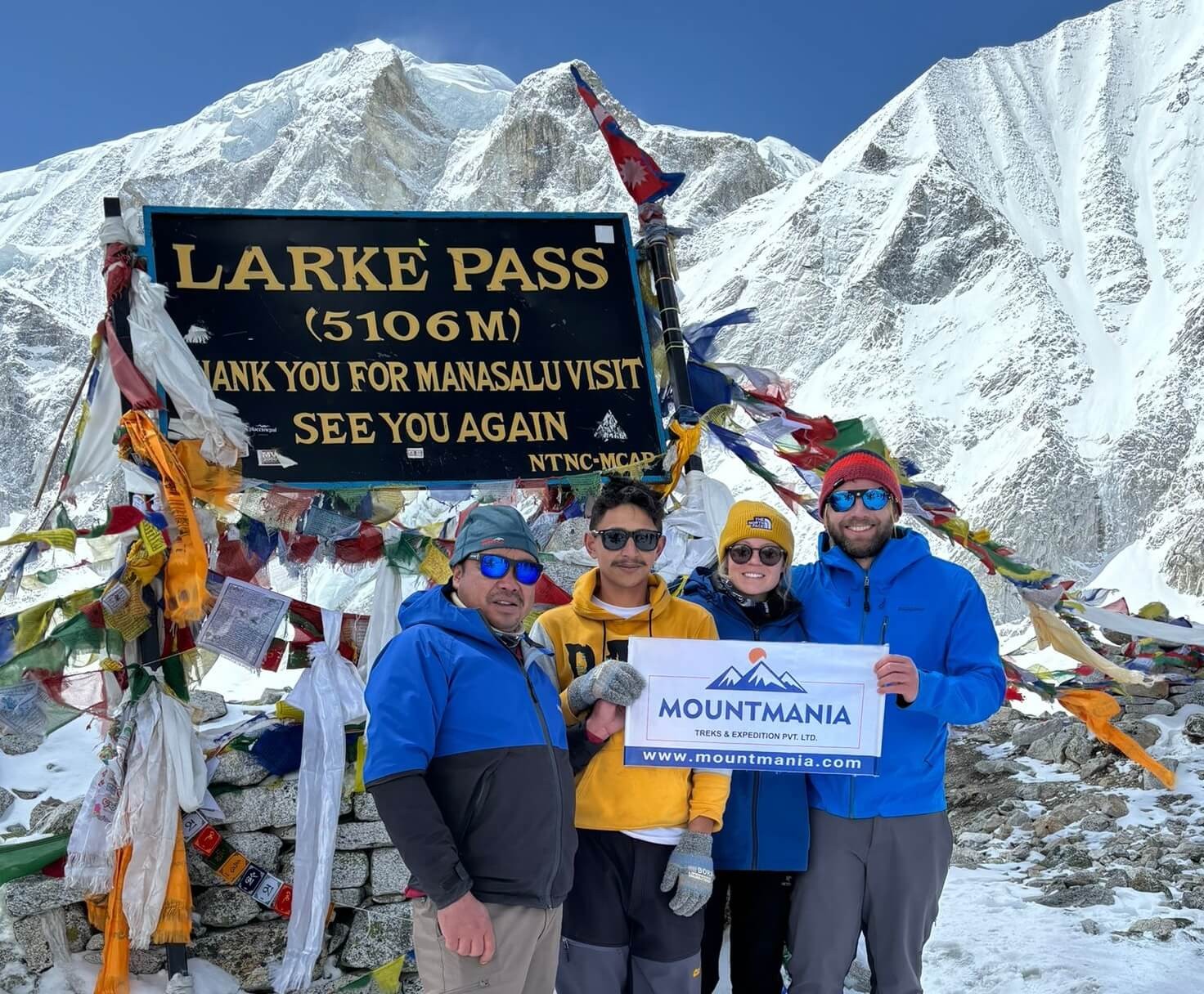
The highest point is the Larkya La Pass, standing at an elevation of 5,106 meters (16,752 ft).
When is the best time to trek in Manaslu?
The best windows are Spring (March to May) for rhododendron blooms and stable weather, and Autumn (September to November) for the clearest mountain views and crisp skies.
Where is Manaslu?
Manaslu is located in the Gorkha District of Nepal, about 64 km east of Annapurna. It is the 8th highest mountain in the world.
How cold is it at Manaslu?
Temperatures vary by altitude. In the lower regions, it's pleasant (15°C to 20°C). However, above 4,000m, nighttime temperatures can drop to -10°C or -15°C, especially during late autumn and early spring.
What kind of food is available?
Tea houses serve a variety of meals including the traditional Dal Bhat (lentils and rice), pasta, noodles, potatoes, eggs, and pancakes. Vegetarian and vegan options are widely available. Read this Manaslu Food Guide
What kind of accommodation is available?
Accommodation consists of local tea houses (mountain lodges). Rooms are usually twin-sharing with basic wooden beds and blankets. They offer a cozy atmosphere and a warm communal dining hall.
I want a single room. What should I do?
We can arrange a single room in Kathmandu and at lower elevations. However, in higher altitudes (like Dharmasala), rooms are limited and sharing may be necessary during peak season.
Is it possible to have a shower on the trek?
Yes, most tea houses offer hot showers for a small additional fee (approx. $3–$5). As you get higher, showers may be "bucket showers" with heated water.
What is the ideal weight for my backpack?
If you are carrying your own gear, aim for 10–12kg. If you have a porter, your daypack should only weigh 4–5kg to carry your water, camera, and essential layers.
What is the weight limit for the porter?
A porter typically carries up to 20–25kg, usually shared between two trekkers (roughly 12kg per person).
Should I be worried about Altitude Sickness?
Altitude Sickness (AMS) is a risk on any trek above 3,000m. We design our itineraries with proper acclimatization days in Samagaun and Samdo to minimize risk. Our guides are trained to monitor your health daily.
How long is the Manaslu Circuit?
The total trekking distance is approximately 177 kilometers (110 miles), usually covered over 12 to 14 days of walking depending on the specific itinerary.
All right! We'll be back! The airport pickup worked out, was punctual and cordial. The check in as well. The organization of the arrival, the tour itself, the accommodations worked great. We can recommend the Enterprise 100%.
Last year we went to the Langtang area.....Balu Acharya was our guide. We got to know him as a very good guide.......always helpfull, frienly and careful....just like a good friend.
Highly recommend this trip! A friend recommended it to me, and I complete understand why. Landscapes are just insane. Ganesh was a great guide, took lots of care of us and adapted the trip to our wishes and needs. Price is also really fair taking into account that everything is included.
My partner and I had the most amazing experience on the Manaslu Circuit Trek in April 2024. We can't thank Mount Mania team enough for taking us on this truly unforgettable adventure. Over 14 days, we journeyed through the Nepalese Himalayas and crossed over the Larke Pass at an elevation of 5106 meters!
The trek had some of the most stunning landscapes we have ever seen. Each day brought new vistas even more breathtaking than the last. The panoramic views from the Larke Pass were a highlight, offering an unparalleled sense of accomplishment and awe. One of the most enriching aspects of the trek was the opportunity to immerse ourselves in the local culture. The teahouses provided a cozy and authentic experience, with delicious home-cooked meals and a chance to learn about the local customs and way of life.
The trek was challenging but incredibly rewarding. The trail was varied, with some steep ascents and descents, river crossings, and suspension bridges. And let's not forget our mountain friends - the beautiful mules, we passed many on this trek. The gradual acclimatization was well-planned, ensuring we were well-prepared for the high altitude of the Larke Pass. Our guide, Ganesh, was knowledgeable and supportive, providing us with invaluable information about the region and ensuring our safety and comfort throughout.
Tips for Future Trekkers:
Physical prep: Make sure to be in good physical condition before attempting the trek. The altitude and duration require a reasonable level of fitness.
Packing: Pack light but ensure you have essential gear for cold weather, particularly for the higher altitudes. A good pair of trekking boots is a must.
Acclimatization: Take this process seriously to avoid altitude sickness. Listen to your guide and your body.
Guided vs. Independent Trekking: We highly recommend going with a guide. Mount Mania are a wonderful team and their knowledge and support are invaluable, particularly in remote areas.
The Manaslu Circuit Trek was a life-changing adventure that exceeded our expectations. The combination of natural beauty, cultural richness, and the sense of achievement made it an experience we will cherish forever. If you're looking for a challenging yet incredibly rewarding trek in Nepal, the Manaslu Circuit should be at the top of your list!

.png)
.png)